VN-300

DUAL GNSS / INS

Introduction

The VN-300 is a miniature, high-performance Dual Antenna GNSS-Aided Inertial Navigation System that combines MEMS inertial sensors, two high-sensitivity GNSS receivers, and advanced Kalman filtering algorithms to provide optimal estimates of position, velocity, and orientation. By utilizing two separate GNSS receivers and antennas, the VN-300 enables accurate heading measurements without reliance on vehicle dynamics or magnetic  sensors, providing unmatched performance under both static and dynamic conditions.

0.15° - 0.3°

GNSS-Compass Heading (1m)

0.2°

Dynamic Heading

0.03°

Dynamic Pitch/Roll

5°/hr

Gyro In-Run Bias

< 0.04 mg

Accel In-Run Bias

±16 g

Accelerometer Range

±2,000˚/sec

Gyroscope Range

400 Hz

IMU Data

400 Hz

Navigation Data

PRODUCT HIGHLIGHTS

Integrated GNSS Compass

For highly accurate heading in static and low dynamic conditions

User Configurable Messages

ASCII, NMEA-0183 & VectorNav Binary messages

INS Filter

Coupled position, velocity and attitude data for optimal dynamic performance.

Ease of Availability

Made in the USA, ITAR-free, & ships within 1 business day

Field Proven

Released in 2014, tens of thousands of units fielded

High Data Outputs

400 Hz Navigation data; 800 Hz IMU data

Ultra Low SWaP

< 21.8 cm3; < 30 grams; < 1.5 W
Overview

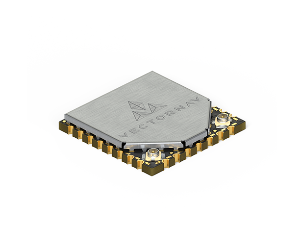
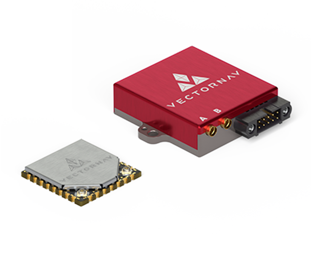
The VN-300 is designed for applications that require highly accurate inertial navigation solution under both static and dynamic operating conditions, especially in environments with unreliable magnetic heading and good GNSS visibility. The VN-300 is the first and only Dual GNSS Antenna Inertial Navigation System in a single surface mount package. At the size of a postage stamp, the VN-300 SMD requires only a single 3.2-5.5V power supply, and can be directly embedded into a user’s electronics for unprecedented SWAP advantages. 

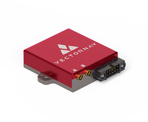
The VN-300 Rugged is the “plug and play” version of the VN-300 SMD. Enclosed in a clamshell precision anodized aluminum enclosure, the VN-300 Rugged offers additional protection of the internal MEMs sensors, GNSS receivers and electronics. Interfacing with the module is made through a locking 10-pin connector, as well as two MMCX connectors for external active GPS antennas.

Packaging Options

VN-300 SMD Front_Small

SMD
Size: 24 x 22 x 3 mm
Power: 185 mA @ 3.3 V
Mass: 5 g

VN-300 Rugged Front_Small

Rugged
Size: 45 x 44 x 11 mm
Power: 250 mA @ 5 V
Mass: 30 g

Sensor Summary:

  • GNSS Compass for static and low dynamic heading accuracy

  • VectorNav Processing Engine (VPE) 2.0 for disturbance rejection, adaptive filtering, dynamic filter tuning

  • Hard/Soft Iron Compensation 

  • Coupled position, velocity and attitude estimates

  • Solid-State MEMS inertial sensors

  • All sensors are individually calibrated for bias, scale factor, misalignment, and temperature over full operating range (-40° C to 85° C)

  • Two x 72 Channel GNSS Receivers:

    • GPS L1 C/A

    • Galileo E1

    • SBAS: L1 C/A

  • Raw Psuedorange, Doppler and carrier phase outputs

  • 400 Hz IMU Data

  • 400 Hz navigation and attitude data

  • Yaw/Pitch/Roll

  • Position and Velocity

  • Coning and sculling integrals (ΔV’s, Δθ’s)

  • Data output format: ASCII (VectorNav), NMEA-0183, Binary (VectorNav)

  • VectorNav Control Center freely available for easy setup, configuration and logging

  • ITAR-Free

Specifications

ATTITUDE

Range (Heading/Yaw, Roll)

± 180°

Range (Pitch)

± 90°

Heading (Magnetic)*1

2.0° RMS

Heading (INS)*2

0.2°, 1σ

Heading (GNSS-Compasss, 1m Baseline)

0.3° RMS

Heading (Typical)*3

0.15° RMS

Pitch/Roll (Static)

0.5° RMS

Pitch/Roll (INS)*2

0.03°, 1σ

Heading Mounting Misalignment (Rugged)*3

0.15°, 1σ

Pitch/Roll Mounting Misalignment*3

<0.1°, 1σ

Angular Resolution

0.001°
POSITION/VELOCITY

Horizontal Position Accuracy*4

1.0 m RMS

Horizontal Position Accuracy (Typical)*4

1.0 m RMS

Vertical Position Accuracy*4

1.5 m RMS

Vertical Position Accuracy (Typical)*4

1.5 m RMS

Free Inertial Position Drift*5

3.0 cm/s2

Velocity Accuracy

< 0.05 m/s
*1With proper magnetic declination, suitable magnetic environment and valid hard/soft iron calibration.
*2With sufficient motion for dynamic alignment.
*3Constant on a per part basis. Can be calibrated out during system integration using boresighting or other alignment processes.
*4With SBAS, clear view of GNSS satellites, good multipath environment, compatible GNSS antenna, and as measured over a 24 hour period.
*5Typical rate of growth in error of position estimates after loss of GNSS signal, provided INS full alignment prior to loss.

Range

±16 g

In-Run Bias Stability

< 0.04 mg

Noise Density

0.14 mg/√Hz

Bandwidth

230 Hz

Cross-Axis Sensitivity

±0.05°

Range

±2,000°/s

In-Run Bias Stability

< 10°/hr (5°/hr typ.)

Noise Density

0.0035°/s /√Hz

Bandwidth

265 Hz

Cross-Axis Sensitivity

< 0.05°

Range

±2.5 Gauss

In-Run Bias Stability

-

Noise Density

140 μGauss/√Hz

Bandwidth

200 HZ

Cross-Axis Sensitivity

±0.05 °

Range

10 to 1200 mbar

In-Run Bias Stability

-

Noise Density

-

Bandwidth

200 Hz

Cross-Axis Sensitivity

-

Receiver Type

(2) 72 Channel, L1 GNSS

Solution Update Rate

5 Hz

Time-to-First-Fix (Cold)

29 s

Time-to-First-Fix (Hot)

1 s

Altitude Limit

50,000 m

Velocity Limit

500 m/s
Surface Mount Device

Size

24 x 22 x 3 mm

Weight

5 g

Interface Connector

30-pin LGA

GNSS Connector

U.FL
Rugged

Size

45 x 44 x 11 mm

Weight

30 g

Interface Connector

10-pin Harwin

GNSS Connector

MMCX
Surface Mount Device

Input Voltage

3.2 to 5.5 V

Current Draw*1

185mA @ 3.3 V

Power*1

< 1.25 W

Digital Interface

Serial TTL, SPI

Baud Rate

Up to 921,600

GNSS PPS

30ns RMS, 60 ns 99%

Input

Sync-In

Output

Sync-Out
Rugged

Input Voltage

3.3 to 14 V

Current Draw*1

150mA @ 5 V

Power*1

1.25 W

Digital Interface

Serial TTL, RS-232

Baud Rate

Up to 921,600

GNSS PPS

30ns RMS, 60 ns 99%

Input

Sync-In

Output

Sync-Out
*1Not including active antenna power consumption.

Operating Temperature

-40° to +85° C

Storage Temperature

-40° to +85° C

MTBF (Rugged)

> 125,000 hours

MTBF (SMD)

> 165,000 hours

DOCUMENTATION AND RESOURCES

TECHNICAL

VN-300 User Manual

DOWNLOAD

VN-300 Datasheet

DOWNLOAD

VN-300 SMD EaglePCB Package

DOWNLOAD

VN-300 Rugged STEP File

DOWNLOAD

VN-300 Rugged Mechanical Drawing

DOWNLOAD
SALES

VectorNav Product Brochure

DOWNLOAD

VN-300 Product Brief

DOWNLOAD

VN-300 Purchasing Guide

DOWNLOAD

SOFTWARE

CONTROL CENTER

The new VectorNav Control Center provides you with a wide assortment of tools to visualize and inspect the wealth of data made available by your VectorNav sensor

DOWNLOAD

PROGRAMMING LIBRARY

The VectorNav programming library consolidates all of the varied programming libraries into a single downloadable package. Currently included programming libraries are:

C, C++, Labview, Matlab, .Net, Python, Unity

DOWNLOAD

EAGLE PCB FILES

The EAGLE Library contains footprints and parts for your schematics and layouts for CadSoft's EAGLE PCB software

DOWNLOAD

Development Kits

VN-300 SMD Development Kit

Everything you need to get started with the VN-300 SMD. The kit includes a development board, VN-300 SMD, two GNSS antennas and interface cables. To purchase the VN-300 SMD Development Kit please click on the link below.

VN-300 Rugged Development Kit

Everything you need to get started with the VN-300 Rugged. The kit includes a VN-300 Rugged, two GNSS antennas, ground planes and interface cables. To purchase the VN-300 Rugged Development Kit please click on the link below.

VECTORNAV INERTIAL NAVIGATION PRIMER

Everything you need to know about inertial navigation.

Contact Us

I am looking for: *
Opt In